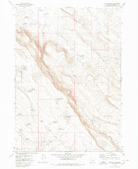
1980 Map of Twin Buttes
USGS Topo · Published 1980About this map
Jackass Creek flows through this high-desert landscape in Harney County, illustrating the vital role of water management in eastern Oregon's interior during the late 20th century. The terrain is defined by the steep elevation changes of Black Rim and the namesake Twin Buttes, which serve as prominent landmarks in an otherwise open expanse.
Find a feature on this map
25 named features on this map. Tap any name to fly to it.
Don’t see what you’re looking for? This feature index may not catch every label — zoom into the map to look around manually.
Map Details
Editions of this 1980 Twin Buttes Map
This is the sole edition of this map. No revisions or reprints were ever made.
Other maps of this area

1955 · Burns
USGS Topo · 1:250,000

1955 · Adel
USGS Topo · 1:250,000

1957 · Adel
USGS Topo · 1:250,000

1958 · Burns
USGS Topo · 1:250,000

1958 · Adel
USGS Topo · 1:250,000

1959 · Burns
USGS Topo · 1:250,000

1962 · Adel
USGS Topo · 1:250,000

1967 · Coyote Buttes
USGS Topo · 1:24,000

1967 · Jackass Butte
USGS Topo · 1:24,000
1967 · Irish Lake
USGS Topo · 1:24,000