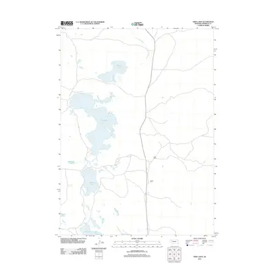
2011 Map of Twin Lakes
USGS Topo · Published 2011About this map
Twin Lakes and a series of smaller alkali basins dominate this Sheridan County landscape, where the high water table of the Nebraska Sandhills creates a network of interior drainage. The area is characterized by large private holdings, including the Speer Ranch and Hooper Ranch, which reflect the region's enduring cattle-ranching heritage. Roads trace the easier paths between the dunes and wetlands, connecting isolated ranchsteads to water sources like Pine Creek. A dense cluster of named lakes, from Cravath Lake in the north to Joy Lake and Goose Lake in the south, provides a detailed record of local hydrologic features and land-naming traditions. Diamond Lake and Albrecht Lake further illustrate the topographic depressions common to this section of the state, where surface water is essential for both livestock and the regional ecosystem.
Find a feature on this map
9 named features on this map. Tap any name to fly to it.
Don’t see what you’re looking for? This feature index may not catch every label — zoom into the map to look around manually.
Map Details
Editions of this 2011 Twin Lakes Map
This is the sole edition of this map. No revisions or reprints were ever made.
Other maps of this area

1948 · Antioch
USGS Topo · 1:62,500

1948 · Lakeside
USGS Topo · 1:62,500

1948 · Twin Lakes
USGS Topo · 1:62,500

1949 · Antioch
USGS Topo · 1:62,500

1950 · Twin Lakes
USGS Topo · 1:62,500

1950 · Lakeside
USGS Topo · 1:62,500

1950 · Skunk Lake
USGS Topo · 1:62,500

1955 · Alliance
USGS Topo · 1:250,000

1957 · Alliance
USGS Topo · 1:250,000

1958 · Alliance
USGS Topo · 1:250,000