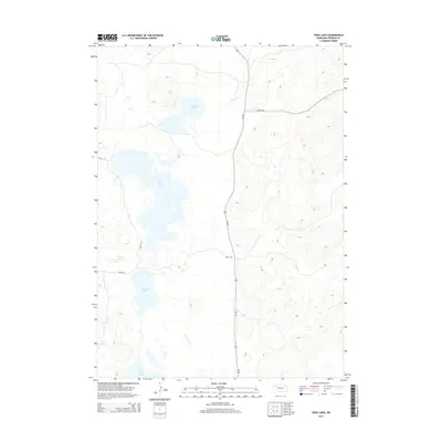
2014 Map of Twin Lakes
USGS Topo · Published 2014About this map
Twin Lakes and a series of scattered basins define this pocket of Sheridan County, where the Sandhills landscape is punctuated by numerous named water bodies. This 2014 survey illustrates a region largely defined by its natural hydrology and a sparse network of trails and rural routes. The central and northern portions of the quadrangle are dominated by Cravath Lake and the winding course of Pine Cr, while the southern expanse features Albrecht Lake, Diamond Lake, Goose Lake, and Joy Lake. These features suggest a landscape where water management and ranching access are primary, connected by local arteries like Ne-250 and various numbered trails such as 358th Trl and 295th Trl. The lack of dense settlement emphasizes the open, agricultural character of this Nebraska territory in the early 21st century.
Find a feature on this map
12 named features on this map. Tap any name to fly to it.
Don’t see what you’re looking for? This feature index may not catch every label — zoom into the map to look around manually.
Map Details
Editions of this 2014 Twin Lakes Map
This is the sole edition of this map. No revisions or reprints were ever made.
Other maps of this area
1948 · Antioch
USGS Topo · 1:62,500
1948 · Lakeside
USGS Topo · 1:62,500
1948 · Twin Lakes
USGS Topo · 1:62,500
1949 · Antioch
USGS Topo · 1:62,500
1950 · Twin Lakes
USGS Topo · 1:62,500
1950 · Lakeside
USGS Topo · 1:62,500
1950 · Skunk Lake
USGS Topo · 1:62,500
1955 · Alliance
USGS Topo · 1:250,000
1957 · Alliance
USGS Topo · 1:250,000
1958 · Alliance
USGS Topo · 1:250,000