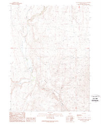
1989 Map of Twin Meadows Ranch
USGS Topo · Published 1989About this map
Twin Meadows Ranch sits at the heart of this high-desert landscape in Elko County, where the North Fork and Salmon Falls Creek converge. The topography is defined by the expansive O'Neil Basin to the west and the intricately eroded Bad Lands to the south. This 1980s survey captures a working ranching environment where water management is paramount, illustrated by the network of drainage through Monkey Creek and Scott Creek. A notable geological landmark, the Natural Arch, is recorded on the eastern edge of the quadrangle, highlighting the area's unique erosional features. The map illustrates how human activity, centered on the ranch, is dictated by the seasonal flow of these northern Nevada waterways.
Find a feature on this map
9 named features on this map. Tap any name to fly to it.
Don’t see what you’re looking for? This feature index may not catch every label — zoom into the map to look around manually.
Map Details
Editions of this 1989 Twin Meadows Ranch Map
This is the sole edition of this map. No revisions or reprints were ever made.
Other maps of this area

1955 · Wells
USGS Topo · 1:250,000

1957 · Contact
USGS Topo · 1:62,500

1957 · Elk Mountain
USGS Topo · 1:62,500

1958 · Wells
USGS Topo · 1:250,000

1961 · Wells
USGS Topo · 1:250,000

1968 · Hubbard Basin
USGS Topo · 1:24,000

1968 · Henry
USGS Topo · 1:24,000
1968 · Gilmer Ranch
USGS Topo · 1:24,000
1981 · Jarbidge Mts
USGS Topo · 1:100,000

1982 · Jackpot
USGS Topo · 1:100,000