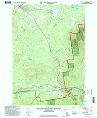
1995 Map of Twin Mountain
USGS Topo · Published 2000About this map
Ammonoosuc River and the Maine Central railroad define the transportation and industrial corridor of this mid-1990s landscape in Coos County. The map documents a transition from traditional land use to modern infrastructure, evidenced by the presence of both the Twin Mountain Fish Hatchery and a Biomass Powerplant near Quebec Junction. Small settlements like Carroll and Twin Mountain serve as hubs for the surrounding White Mountain region, while the White Mountain National Forest boundary marks the shift into more preserved terrain.
Find a feature on this map
53 named features on this map. Tap any name to fly to it.
Don’t see what you’re looking for? This feature index may not catch every label — zoom into the map to look around manually.
Map Details
Editions of this 1995 Twin Mountain Map
This is the sole edition of this map. No revisions or reprints were ever made.
Other maps of this area

1893 · Mt. Washington
USGS Topo · 1:62,500

1895 · Crawford Notch
USGS Topo · 1:62,500

1896 · Mt. Washington
USGS Topo · 1:62,500

1896 · Crawford Notch
USGS Topo · 1:62,500

1900 · Whitefield
USGS Topo · 1:62,500

1929 · Franconia
USGS Topo · 1:62,500

1932 · Franconia
USGS Topo · 1:62,500

1935 · Whitefield
USGS Topo · 1:48,000

1935 · Mt. Washington
USGS Topo · 1:62,500
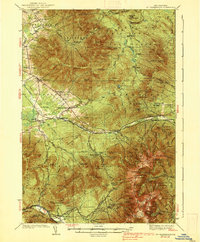
1938 · Mt. Washington
USGS Topo · 1:62,500