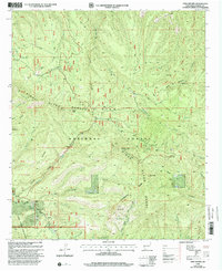
1999 Map of Twin Sisters
USGS Topo · Published 2002About this map
Pinos Altos Range summits dominate this high-elevation portion of the Gila National Forest in Grant County. Mapping in the late 1990s captures a landscape defined by sharp topographical relief and a network of historical transport routes, including the Sawmill Wagon Road and Wagon Road traversing the southern slopes. High points such as Signal Peak Lookout, Scott Peak, and the namesake Twin Sisters provide strategic vantages over the complex drainage systems of Trout Creek, Meadow Creek, and Cherry Creek. This survey reflects the intersection of traditional land use and modern recreation, showing numerous prospects and mines alongside the Continental Divide National Scenic Trail. The presence of a Scenic Byway and various secluded water sources like Seep and Spring further characterize this high-country terrain.
Find a feature on this map
39 named features on this map. Tap any name to fly to it.
Don’t see what you’re looking for? This feature index may not catch every label — zoom into the map to look around manually.
Map Details
Editions of this 1999 Twin Sisters Map
This is the sole edition of this map. No revisions or reprints were ever made.
Other maps of this area

1909 · Silver City
USGS Topo · 1:125,000

1911 · Alum Mountain
USGS Topo · 1:125,000

1913 · Alum Mountain
USGS Topo · 1:125,000

1937 · Santa Rita
USGS Topo · 1:24,000

1947 · Allie Canyon
USGS Topo · 1:24,000

1947 · Twin Sisters
USGS Topo · 1:24,000

1947 · Fort Bayard
USGS Topo · 1:24,000

1948 · Twin Sisters
USGS Topo · 1:24,000

1948 · Santa Rita
USGS Topo · 1:24,000

1948 · Allie Canyon
USGS Topo · 1:24,000