
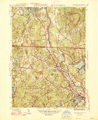
1946 Map of Tyngsboro
USGS Topo · Published 1946About this map
The Merrimack River snakes through the heart of this mid-1940s landscape, serving as a corridor for the Boston and Maine RR and defining the boundary between established towns and rural uplands. In Tyngsboro, the river is framed by prominent heights like Abrams Hill and Potash Hill, while the Notre Dame Academy sits near the river's bend. To the north, the urban edge of Nashua and Hudson begins to show the leisure patterns of the era with the Nashua Country Club.
Find a feature on this map
95 named features on this map. Tap any name to fly to it.
Don’t see what you’re looking for? This feature index may not catch every label — zoom into the map to look around manually.
Map Details
Editions of this 1946 Tyngsboro Map
2 editions found
Other maps of this area

1886 · Lowell
USGS Topo · 1:62,500

1893 · Lowell
USGS Topo · 1:62,500

1893 · Groton
USGS Topo · 1:62,500

1905 · Manchester
USGS Topo · 1:62,500

1906 · Milford
USGS Topo · 1:62,500

1918 · Lowell
USGS Topo · 1:62,500

1921 · Lowell
USGS Topo · 1:62,500
1931 · Lowell
USGS Topo · 1:48,000

1931 · Groton
USGS Topo · 1:48,000

1935 · Ayer
USGS Topo · 1:24,000