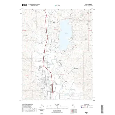
2018 Map of Ukiah
USGS Topo · Published 2018About this map
The Russian River and its East Fork define the geography of the Ukiah Valley in this 2018 survey, where the massive reservoir of Lake Mendocino rests against the Mayacmas Mountains. The city of Ukiah serves as the central hub, surrounded by smaller settlements such as Calpella, Talmage, and Rogina Heights. Transportation and industry are clearly etched into the landscape via the US Highway 101 corridor and the Northwestern Pacific Railroad, which parallel the river's path. Local history and genealogy interests are well-served by the inclusion of the Ukiah Cemetery and the notable Asylum site south of town. The transition from the valley floor to the surrounding heights is marked by landmarks like Mendocino College and the eastern slopes of Cow Mountain, providing a comprehensive look at the modern footprint of this Mendocino County seat.
Find a feature on this map
171 named features on this map. Tap any name to fly to it.
Don’t see what you’re looking for? This feature index may not catch every label — zoom into the map to look around manually.
Map Details
Editions of this 2018 Ukiah Map
This is the sole edition of this map. No revisions or reprints were ever made.
Other maps of this area

1920 · Ukiah
USGS Topo · 1:62,500

1922 · Willits
USGS Topo · 1:62,500

1942 · Willits
USGS Topo · 1:62,500

1943 · Pomo
USGS Topo · 1:62,500

1943 · Boonville
USGS Topo · 1:62,500

1944 · Ukiah
USGS Topo · 1:62,500

1944 · Willits
USGS Topo · 1:62,500

1957 · Ukiah
USGS Topo · 1:250,000
1958 · Purdys Gardens
USGS Topo · 1:24,000

1958 · Ukiah
USGS Topo · 1:24,000