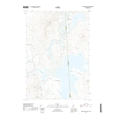
2018 Map of Umbagog Lake North
USGS Topo · Published 2018About this map
The Magalloway River and Androscoggin River converge north of Umbagog Lake in this northern forest study along the New Hampshire and Maine state line. The landscape is defined by its glacial hydrology, featuring numerous isolated water bodies like Dustan Pond, Bear Brook Pond, and Mountain-Pond tucked between significant elevations. Peaks such as Mt Dustan and Sturtevant Mtn overlook a complex of wetlands including Sweat Meadows. Human presence is marked by the Magalloway Church Cem and a network of logging roads and trails, such as the Eames Trail and Dead Diamond Rd, which navigate the dense terrain and numerous coves like Sunday Cove and Black Island Cove. This survey documents a critical junction where the northern headwaters of the Androscoggin form, illustrating the transition from steep mountain slopes to the expansive marshlands and lake shores of the Coos and Oxford county border.
Find a feature on this map
48 named features on this map. Tap any name to fly to it.
Don’t see what you’re looking for? This feature index may not catch every label — zoom into the map to look around manually.
Map Details
Editions of this 2018 Umbagog Lake North Map
This is the sole edition of this map. No revisions or reprints were ever made.
Other maps of this area

1930 · Milan
USGS Topo · 1:62,500

1930 · Errol
USGS Topo · 1:62,500

1933 · Milan
USGS Topo · 1:62,500

1934 · Errol
USGS Topo · 1:62,500

1934 · Milan
USGS Topo · 1:62,500

1940 · Oquossoc
USGS Topo · 1:62,500

1942 · Oquossoc
USGS Topo · 1:62,500

1943 · Old Speck Mtn
USGS Topo · 1:62,500

1945 · Old Speck Mtn
USGS Topo · 1:62,500

1950 · Lewiston
USGS Topo · 1:250,000