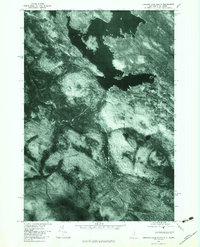
1976 Map of Umbagog Lake South
USGS Topo · Published 1983About this map
Umbagog Lake dominates the northern expanse of this 1976 orthophotograph, its dark waters contrasting sharply with the dense forest cover of the surrounding Hampshire Hills. The aerial perspective reveals the intricate shoreline and drainage patterns of the region, where the winding Mollidgewock Brook and Bog Brook carve through the timberland.
Find a feature on this map
7 named features on this map. Tap any name to fly to it.
Don’t see what you’re looking for? This feature index may not catch every label — zoom into the map to look around manually.
Map Details
Editions of this 1976 Umbagog Lake South Map
This is the sole edition of this map. No revisions or reprints were ever made.
Other maps of this area

1930 · Milan
USGS Topo · 1:62,500

1930 · Errol
USGS Topo · 1:62,500

1933 · Milan
USGS Topo · 1:62,500

1934 · Errol
USGS Topo · 1:62,500

1934 · Milan
USGS Topo · 1:62,500

1940 · Oquossoc
USGS Topo · 1:62,500

1942 · Oquossoc
USGS Topo · 1:62,500

1943 · Old Speck Mtn
USGS Topo · 1:62,500

1945 · Old Speck Mtn
USGS Topo · 1:62,500

1950 · Lewiston
USGS Topo · 1:250,000