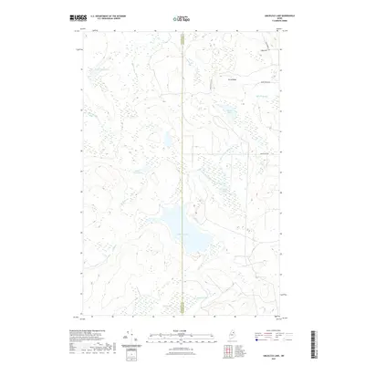
2021 Map of Umcolcus Lake
USGS Topo · Published 2021About this map
Umcolcus Lake dominates this northern Maine landscape, serving as the central drainage point for a complex network of waterways including Cut Brook and the East Branch Umcolcus Stream. The terrain is defined by low-lying wetlands like Wadleigh Bog and the elevated prominence of Yerxa Ridge to the northeast. This 2021 survey reveals a remote timberland environment where human activity is primarily represented by specialized logging and access routes such as Camp Violette Rd and Boody Brook Rd. The map illustrates the boundary between Penobscot and Aroostook counties as it bisects several smaller water bodies, including Smith Pond and Beaver Pond. These features highlight the importance of water resources in defining land use and geographic limits in this unsettled interior region.
Find a feature on this map
20 named features on this map. Tap any name to fly to it.
Don’t see what you’re looking for? This feature index may not catch every label — zoom into the map to look around manually.
Map Details
Editions of this 2021 Umcolcus Lake Map
This is the sole edition of this map. No revisions or reprints were ever made.
Other maps of this area

1940 · Island Falls
USGS Topo · 1:62,500

1940 · Oxbow
USGS Topo · 1:62,500

1942 · Island Falls
USGS Topo · 1:62,500

1942 · Oxbow
USGS Topo · 1:62,500

1954 · Shin Pond
USGS Topo · 1:62,500

1954 · Grand Lake Seboeis
USGS Topo · 1:62,500

1954 · Presque Isle
USGS Topo · 1:250,000

1958 · Presque Isle
USGS Topo · 1:250,000

1960 · Presque Isle
USGS Topo · 1:250,000
1965 · Oxbow
USGS Topo · 1:62,500