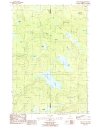
1986 Map of Umcolcus Lake
USGS Topo · Published 1987About this map
The boundary between Penobscot and Aroostook counties bisects this remote timberland landscape in the mid-1980s. Defined by the winding Umcolcus Lake and its associated Umcolcus Stream, the area shows a complex network of glacial hydrology, from the wide Wadleigh Bog in the south to McGilury Pond in the northwest. The terrain is marked by prominent elevations like Yerxa Ridge and Oak Hill, while smaller features such as Black Cat Pd and Cranberry Pond are tucked into the drainages of the East Branch and Dead Brook. Resource extraction is evident in several scattered Shale Pits, but the primary character of this quadrangle remains centered on the unpopulated townships of the Maine woods, including T 8 R 6 Wels and T 7 R 5 Wels.
Find a feature on this map
24 named features on this map. Tap any name to fly to it.
Don’t see what you’re looking for? This feature index may not catch every label — zoom into the map to look around manually.
Map Details
Editions of this 1986 Umcolcus Lake Map
This is the sole edition of this map. No revisions or reprints were ever made.
Other maps of this area

1940 · Island Falls
USGS Topo · 1:62,500

1940 · Oxbow
USGS Topo · 1:62,500

1942 · Island Falls
USGS Topo · 1:62,500

1942 · Oxbow
USGS Topo · 1:62,500

1954 · Shin Pond
USGS Topo · 1:62,500

1954 · Grand Lake Seboeis
USGS Topo · 1:62,500

1954 · Presque Isle
USGS Topo · 1:250,000

1958 · Presque Isle
USGS Topo · 1:250,000

1960 · Presque Isle
USGS Topo · 1:250,000
1965 · Oxbow
USGS Topo · 1:62,500