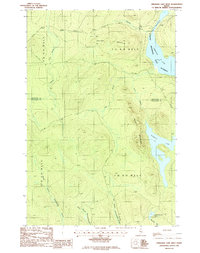
1986 Map of Umsaskis Lake West
USGS Topo · Published 1987About this map
The Allagash Wilderness State Waterway defines this remote stretch of the North Woods, where the waters of Umsaskis Lake and Priestly Lake dominate the landscape. In the mid-1980s, the area remained largely undeveloped, characterized by a complex network of stream branches including the Middle Branch, North Branch, and East Branch Thoroughfare Brook. This hydrography is framed by the prominence of Squirrel Mountain and Priestly Mountain.
Find a feature on this map
26 named features on this map. Tap any name to fly to it.
Don’t see what you’re looking for? This feature index may not catch every label — zoom into the map to look around manually.
Map Details
Editions of this 1986 Umsaskis Lake West Map
This is the sole edition of this map. No revisions or reprints were ever made.
Other maps of this area

1932 · Umsaskis Lake
USGS Topo · 1:48,000

1935 · Umsaskis Lake
USGS Topo · 1:62,500

1954 · Churchill Lake
USGS Topo · 1:62,500

1954 · Allagash Lake
USGS Topo · 1:62,500

1954 · Presque Isle
USGS Topo · 1:250,000

1955 · Clayton Lake
USGS Topo · 1:62,500

1958 · Presque Isle
USGS Topo · 1:250,000

1960 · Presque Isle
USGS Topo · 1:250,000

1961 · Allagash Lake
USGS Topo · 1:62,500
1962 · Churchill Lake
USGS Topo · 1:62,500