2023 Map of Unadilla Forks
USGS Topo · Published 2023About this map
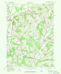
The Unadilla River flows southward through the heart of this Central New York landscape, carving a valley that separates the uplands of Otsego, Madison, and Herkimer Counties. The settlement at Unadilla Forks serves as a geographic anchor where the river meets Campbell Brook, surrounded by a high density of ancestral burial grounds such as Unadilla Forks Cem and Wood Cem. To the east, the terrain rises toward peaks like Mount Markham and Noahs Rump, while small hamlets like Huntly Corners and Plainfield Center dot the high ground. The map details a network of rural routes, including the Skaneateles Tpke, which connect these agricultural outposts to the valley floor. In the southern reach, the headwaters of Wharton Creek and the quiet waters of Summit Lake define the drainage patterns of a region still characterized by dispersed farmsteads and historic crossroad communities.
Find a feature on this map
86 named features on this map. Tap any name to fly to it.
Don’t see what you’re looking for? This feature index may not catch every label — zoom into the map to look around manually.
Map Details
Editions of this 2023 Unadilla Forks Map
This is the sole edition of this map. No revisions or reprints were ever made.
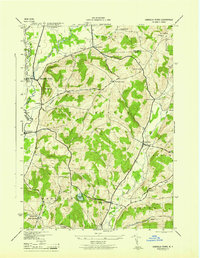
Historical Maps of North Edmeston Through Time
3 maps found