
Loading...
Loading map...2023 Map of Union Springs
USGS Topo · Published 2023About this map
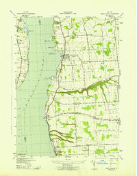
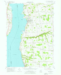
Cayuga Lake dominates this eastern shore landscape, where the lakefront villages of Union Springs and Aurora serve as primary anchors for the local community. The terrain is defined by deep incisions such as Great Gully and Glen Creek, which cut through the limestone-rich topography of Cayuga County. In Union Springs, a cluster of historical burial grounds including Oak Ridge Cem, Saint Michaels Cem, and Chestnut Hill Cem reflects the long-standing settlement of the area.
Find a feature on this map
82 named features on this map. Tap any name to fly to it.
Don’t see what you’re looking for? This feature index may not catch every label — zoom into the map to look around manually.
Map Details
Date Portrayed2023
Date Published2023
PublisherU.S. Geological Survey
Map TypeTopographic
Scale1:24000
Physical Dimensions24 x 29 inches
Editions of this 2023 Union Springs Map
This is the sole edition of this map. No revisions or reprints were ever made.
Historical Maps of Farleys Through Time
3 maps found
Featured Locations
Source Details
SourceU.S. Geological Survey
CopyrightPublic Domain