1999 Map of Unionville
USGS Topo · Published 2001About this map
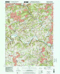
The confluence of the West Branch Brandywine Creek and the East Branch Brandywine Creek anchors this section of Chester County, where the landscape transitions from the industrial corridor of Downingtown in the north to the rolling horse country of Unionville in the south. The rural character of the late 20th century is punctuated by long-standing institutional landmarks, including the County Prison and the Pocopson Home located near Pocopson Creek. Historic industrial remnants like Savery's Mill near Parkerville sit alongside modern infrastructure such as the Radio Range Sta and a sprawling Filtration Plant.
Find a feature on this map
65 named features on this map. Tap any name to fly to it.
Don’t see what you’re looking for? This feature index may not catch every label — zoom into the map to look around manually.
Map Details
Editions of this 1999 Unionville Map
This is the sole edition of this map. No revisions or reprints were ever made.
Other maps of this area

1901 · West Chester
USGS Topo · 1:62,500

1904 · West Chester
USGS Topo · 1:62,500

1904 · Coatesville
USGS Topo · 1:62,500

1905 · Honey Brook
USGS Topo · 1:62,500

1906 · Phoenixville
USGS Topo · 1:62,500

1906 · Coatesville
USGS Topo · 1:62,500

1907 · Honeybrook
USGS Topo · 1:62,500

1918 · Coatesville
USGS Topo · 1:62,500

1941 · Honeybrook
USGS Topo · 1:62,500

1943 · Coatesville
USGS Topo · 1:62,500
Featured Places
- West Goshen Township, PA
- Caln Township, PA
- Birmingham Township, PA
- Pocopson Township, PA
- Unionville, East Marlborough Township