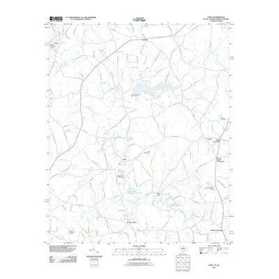
2011 Map of Unity
USGS Topo · Published 2011About this map
Cane Creek and its complex network of tributaries define the topography of this South Carolina and North Carolina borderland. The landscape is characterized by its agricultural junctions and small rural settlements, most notably the community of Unity and the strategically placed Sapps Crossroads. Aviation history is well-represented through the Unity Aerodrome and the Jaars-Townsend Airport near the northern boundary.
Find a feature on this map
133 named features on this map. Tap any name to fly to it.
Don’t see what you’re looking for? This feature index may not catch every label — zoom into the map to look around manually.
Map Details
Editions of this 2011 Unity Map
This is the sole edition of this map. No revisions or reprints were ever made.
Other maps of this area

1941 · Spartanburg
USGS Topo · 1:250,000

1953 · Spartanburg
USGS Topo · 1:250,000

1960 · Spartanburg
USGS Topo · 1:250,000

1963 · Spartanburg
USGS Topo · 1:250,000

1964 · Spartanburg
USGS Topo · 1:250,000

1968 · Van Wyck
USGS Topo · 1:24,000
1968 · Catawba NE
USGS Topo · 1:24,000

1969 · Antioch
USGS Topo · 1:24,000
1969 · Lancaster
USGS Topo · 1:24,000
1969 · Taxahaw
USGS Topo · 1:24,000