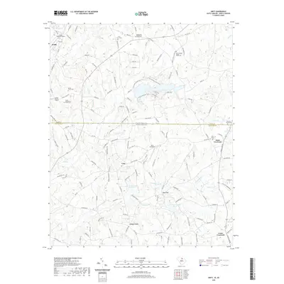
2020 Map of Unity
USGS Topo · Published 2020About this map
The borderlands of Union and Lancaster counties are defined here by a dense network of country roads and family-named landmarks. The landscape is dotted with centers of community worship and memory, including Walkersville Presbyterian Church Cem and the Tirzah Presbyterian Church Cem. Aviation is surprisingly prominent in this rural setting, with facilities like the JAARS-Townsend Airport and the Unity Aerodrome serving the region. Small rural hubs such as Sapps Crossroads and Lingles Crossroads anchor the eastern side of the map, while numerous small waterways like Cane Cr and Waxhaw Cr drain the rolling terrain. This 2020 record captures the enduring rural character of the South Carolina-North Carolina state line, where modern infrastructure meets long-established settlements and cemeteries.
Find a feature on this map
154 named features on this map. Tap any name to fly to it.
Don’t see what you’re looking for? This feature index may not catch every label — zoom into the map to look around manually.
Map Details
Editions of this 2020 Unity Map
This is the sole edition of this map. No revisions or reprints were ever made.
Other maps of this area

1941 · Spartanburg
USGS Topo · 1:250,000

1953 · Spartanburg
USGS Topo · 1:250,000

1960 · Spartanburg
USGS Topo · 1:250,000

1963 · Spartanburg
USGS Topo · 1:250,000

1964 · Spartanburg
USGS Topo · 1:250,000

1968 · Van Wyck
USGS Topo · 1:24,000
1968 · Catawba NE
USGS Topo · 1:24,000

1969 · Antioch
USGS Topo · 1:24,000
1969 · Lancaster
USGS Topo · 1:24,000
1969 · Taxahaw
USGS Topo · 1:24,000