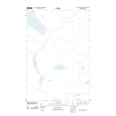
2011 Map of Upper Russell Pond
USGS Topo · Published 2011About this map
Upper Russell Pond and the surrounding North Maine Woods of Piscataquis County are defined by a complex network of waterways feeding the Allagash wilderness. This 2011 survey captures the hydrological character of the T9 R15 WELS township, showing the interconnected basins of Middle Russell Pond, Lower Russell Pond, and Crescent Pond. The prominence of Boise Cascade Rd cutting through the center of the sheet reflects the active timber industry and land management history of this territory. Higher elevations such as Mud Pond Ridge separate the various drainages, including the East Branch Allagash Stream and the winding course of Snare Brook. The map reveals the precise shoreline of Chemquasabamticook Lake and smaller, isolated water bodies like Narrow Pond, providing a detailed record of the region’s topography before further shifts in forest management or natural shoreline erosion occur.
Find a feature on this map
19 named features on this map. Tap any name to fly to it.
Don’t see what you’re looking for? This feature index may not catch every label — zoom into the map to look around manually.
Map Details
Editions of this 2011 Upper Russell Pond Map
This is the sole edition of this map. No revisions or reprints were ever made.
Other maps of this area

1932 · Umsaskis Lake
USGS Topo · 1:48,000

1935 · Umsaskis Lake
USGS Topo · 1:62,500

1954 · Churchill Lake
USGS Topo · 1:62,500

1954 · Allagash Lake
USGS Topo · 1:62,500

1954 · Presque Isle
USGS Topo · 1:250,000

1955 · Clayton Lake
USGS Topo · 1:62,500

1958 · Presque Isle
USGS Topo · 1:250,000

1960 · Presque Isle
USGS Topo · 1:250,000

1961 · Allagash Lake
USGS Topo · 1:62,500
1962 · Churchill Lake
USGS Topo · 1:62,500