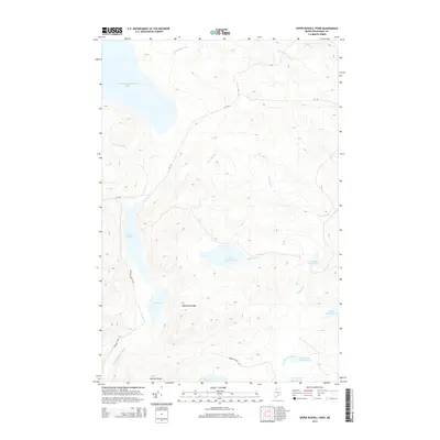
2014 Map of Upper Russell Pond
USGS Topo · Published 2014About this map
Chemquasabamticook Lake anchors the northwest corner of this remote Maine landscape, where a dense network of waterways defines the territory of T9 R15 WELS. The hydrology of the region is characterized by a string of interconnected basins, including Upper Russell Pond, Middle Russell Pond, and Lower Russell Pond, which feed into the larger drainage systems. Significant topographical features like Mud Pond Ridge and the sharply defined Narrow Ridge provide the structural backdrop to these glacial waters. Human imprint is minimal but purposeful, consisting primarily of utility routes such as Cyr Rd and Crescent Pond Rd, which skirt the edges of Crescent Pond and other isolated water bodies. The presence of E Br Allagash Stream and S Br Russell Brook suggests a terrain that remains vital for Northwoods water shed management and backwoods navigation.
Find a feature on this map
21 named features on this map. Tap any name to fly to it.
Don’t see what you’re looking for? This feature index may not catch every label — zoom into the map to look around manually.
Map Details
Editions of this 2014 Upper Russell Pond Map
This is the sole edition of this map. No revisions or reprints were ever made.
Other maps of this area

1932 · Umsaskis Lake
USGS Topo · 1:48,000

1935 · Umsaskis Lake
USGS Topo · 1:62,500

1954 · Churchill Lake
USGS Topo · 1:62,500

1954 · Allagash Lake
USGS Topo · 1:62,500

1954 · Presque Isle
USGS Topo · 1:250,000

1955 · Clayton Lake
USGS Topo · 1:62,500

1958 · Presque Isle
USGS Topo · 1:250,000

1960 · Presque Isle
USGS Topo · 1:250,000

1961 · Allagash Lake
USGS Topo · 1:62,500
1962 · Churchill Lake
USGS Topo · 1:62,500