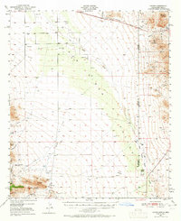
1950 Map of Vanar
USGS Topo · Published 1965About this map
The San Simon Valley defines this arid borderland landscape where the high desert of Arizona meets New Mexico. This mid-century survey illustrates a rugged ranching and mining environment, centered on the Southern Pacific railroad corridor. Near the tracks, the small settlements of Vanar and Steins sit amidst a network of wells and pipelines crucial for sustaining life in the basin. The eastern edge of the map, particularly near Steins Mtn, reveals a history of extraction with the Granite Quarry and the Mineral Mountain Mine. To the south, the terrain rises sharply into the Coronado National Forest, where prominent landmarks like San Simon Head and Blue Mtn overlook a series of deep drainages including Brushy Canyon and Keating Creek. The presence of the San Simon Cienega and Cienega Ranch highlights the importance of rare water sources and early landing strips in this remote interstate region.
Find a feature on this map
30 named features on this map. Tap any name to fly to it.
Don’t see what you’re looking for? This feature index may not catch every label — zoom into the map to look around manually.
Map Details
Editions of this 1950 Vanar Map
3 editions found

Other maps of this area

1917 · San Simon
USGS Topo · 1:125,000

1917 · Chiricahua
USGS Topo · 1:125,000

1918 · Pratt
USGS Topo · 1:62,500

1919 · Pratt
USGS Topo · 1:62,500

1919 · Chiricahua
USGS Topo · 1:125,000

1926 · Cochise Head
USGS Topo · 1:62,500

1926 · Rodeo
USGS Topo · 1:62,500

1926 · Rucker
USGS Topo · 1:62,500

1926 · Orange Butte
USGS Topo · 1:62,500

1928 · Chenoweth
USGS Topo · 1:62,500