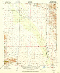
1951 Map of Vanar
USGS Topo · Published 1951About this map
San Simon Valley defines this arid landscape along the Arizona-New Mexico border, where the Southern Pacific railroad runs through the small settlement of Vanar. The terrain is marked by the steep rise of the Peloncillo Mountains to the east and the rugged southern peaks within the Coronado National Forest, including Blue Mtn and the distinctive The Nippers. This 1951 survey reveals a landscape of industrial transitions and remote ranching life. Active and idle mining operations dot the foothills, such as the Ajax Mine and the Granite Quarry, while the Cienega Ranch and a nearby Landing Strip indicate the ranching infrastructure established near the state line. Water management is central to the area's survival, evidenced by the network of seasonal drainages like San Simon Creek and Whitetail Creek that cut across the alluvial flats.
Find a feature on this map
29 named features on this map. Tap any name to fly to it.
Don’t see what you’re looking for? This feature index may not catch every label — zoom into the map to look around manually.
Map Details
Editions of this 1951 Vanar Map
2 editions found

Other maps of this area

1917 · San Simon
USGS Topo · 1:125,000

1917 · Chiricahua
USGS Topo · 1:125,000

1918 · Pratt
USGS Topo · 1:62,500

1919 · Pratt
USGS Topo · 1:62,500

1919 · Chiricahua
USGS Topo · 1:125,000

1926 · Cochise Head
USGS Topo · 1:62,500

1926 · Rodeo
USGS Topo · 1:62,500

1926 · Rucker
USGS Topo · 1:62,500

1926 · Orange Butte
USGS Topo · 1:62,500

1928 · Chenoweth
USGS Topo · 1:62,500