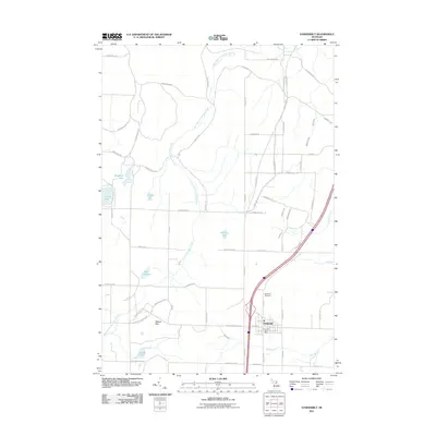
2011 Map of Vanderbilt
USGS Topo · Published 2011About this map
The village of Vanderbilt serves as the central hub of this northern Michigan landscape, characterized by its position along the primary transportation corridors and the winding course of the West Branch Sturgeon River. The local geography is defined by a series of kettle lakes and streams, including Lake Eighteen, Standard Lake, and the expansive Thumb Lake. These water bodies, along with smaller features like Club Stream and Blackjack Creek, reflect the glacial heritage of the Otsego County terrain. For those tracing local heritage, the map clearly identifies the Vanderbilt Post Office and the Vanderbilt Cemetery, providing specific points of reference for the community's history. To the west, the settlement of Watson Hills sits near the river, while the road network, including historic routes like Old 27 Hwy N and S Straits Hwy, illustrates the region's connection to the broader Straits of Mackinac passage.
Find a feature on this map
61 named features on this map. Tap any name to fly to it.
Don’t see what you’re looking for? This feature index may not catch every label — zoom into the map to look around manually.
Map Details
Editions of this 2011 Vanderbilt Map
This is the sole edition of this map. No revisions or reprints were ever made.
Other maps of this area

1954 · Gaylord
USGS Topo · 1:62,500

1955 · Cheboygan
USGS Topo · 1:250,000

1957 · Wolverine
USGS Topo · 1:62,500

1958 · Cheboygan
USGS Topo · 1:250,000

1958 · Petoskey
USGS Topo · 1:62,500

1961 · Boyne Falls
USGS Topo · 1:62,500
1975 · Gaylord SW
USGS Topo · 1:24,000

1982 · Petoskey
USGS Topo · 1:100,000
1983 · Epsilon
USGS Topo · 1:25,000
1986 · Thumb Lake
USGS Topo · 1:24,000