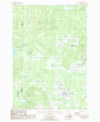
1986 Map of Vanderbilt
USGS Topo · Published 1986About this map
The village of Vanderbilt sits at the southern edge of this mid-1980s landscape, serving as a gateway to the dense timberlands of the Mackinaw State Forest. The geography is defined by a network of glacial lakes and shifting waterways, most notably the Sturgeon River and its West Branch, which carve through the Watson Hills. The area's industrial and transit history is etched into the terrain by an Old Railroad Grade and several resource extraction sites, including a Gravel Pit and Sand Pit. Local history researchers will find several well-defined landmarks, from the Cem near the village to secluded water bodies like Thumb Lake and Lake Eighteen. The map illustrates a transitional period where former timber rail lines were becoming part of the recreational landscape within the boundaries of Chandler, Corwith, and Hudson townships.
Find a feature on this map
29 named features on this map. Tap any name to fly to it.
Don’t see what you’re looking for? This feature index may not catch every label — zoom into the map to look around manually.
Map Details
Editions of this 1986 Vanderbilt Map
This is the sole edition of this map. No revisions or reprints were ever made.
Other maps of this area

1954 · Gaylord
USGS Topo · 1:62,500

1955 · Cheboygan
USGS Topo · 1:250,000

1957 · Wolverine
USGS Topo · 1:62,500

1958 · Cheboygan
USGS Topo · 1:250,000

1958 · Petoskey
USGS Topo · 1:62,500

1961 · Boyne Falls
USGS Topo · 1:62,500
1975 · Gaylord SW
USGS Topo · 1:24,000

1982 · Petoskey
USGS Topo · 1:100,000
1983 · Epsilon
USGS Topo · 1:25,000
1986 · Thumb Lake
USGS Topo · 1:24,000