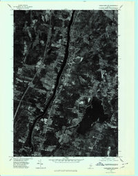
1975 Map of Vassalboro NW
USGS Topo · Published 1980About this map
Kennebec County land use and vegetation patterns are visible in high detail on this 1975 orthophotoquad. The landscape is defined by the central river corridor separating the communities of North Sidney and Sidney on the west bank from Vassalboro and North Vassalboro to the east. The aerial photography reveals the dense cluster of structures at Riverside and the irregular shoreline of Webber Pond. Because this is a photographic map rather than a traditional line drawing, it provides a clear view of woodlots, open fields, and the exact footprints of rural homesteads during the mid-1970s. Transportation infrastructure is represented by the narrow tracks leading toward Mc Coy Crossing, showing how the local road and rail networks integrated with the natural terrain.
Find a feature on this map
7 named features on this map. Tap any name to fly to it.
Don’t see what you’re looking for? This feature index may not catch every label — zoom into the map to look around manually.
Map Details
Editions of this 1975 Vassalboro NW Map
This is the sole edition of this map. No revisions or reprints were ever made.
Other maps of this area

1892 · Waterville
USGS Topo · 1:62,500

1892 · Augusta
USGS Topo · 1:62,500

1893 · Vassalboro
USGS Topo · 1:62,500

1894 · Norridgewock
USGS Topo · 1:62,500

1898 · Norridgewock
USGS Topo · 1:62,500

1898 · Vassalboro
USGS Topo · 1:62,500

1941 · Vassalboro
USGS Topo · 1:62,500

1941 · Augusta
USGS Topo · 1:62,500

1943 · Augusta
USGS Topo · 1:62,500

1943 · Vassalboro
USGS Topo · 1:62,500