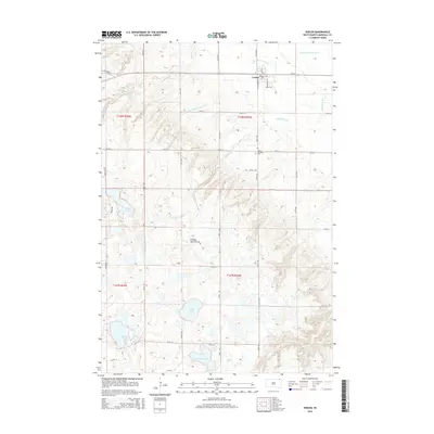
2015 Map of Veblen
USGS Topo · Published 2015About this map
Veblen serves as the primary hub in this corner of Marshall County, situated along the upper reaches of the Little Minnesota River. The landscape is dominated by the Coteau des Prairies, a high glacial plateau that creates a complex drainage system of small creeks and numerous wetlands. To the south of the settlement, the terrain is dotted with significant bodies of water including Hill Lake, Summit Lake, and the larger Turtlefoot Lake.
Find a feature on this map
35 named features on this map. Tap any name to fly to it.
Don’t see what you’re looking for? This feature index may not catch every label — zoom into the map to look around manually.
Map Details
Editions of this 2015 Veblen Map
This is the sole edition of this map. No revisions or reprints were ever made.
Other maps of this area

1953 · Milbank
USGS Topo · 1:250,000

1958 · Milbank
USGS Topo · 1:250,000

1958 · Hillhead
USGS Topo · 1:24,000

1958 · Veblen
USGS Topo · 1:24,000

1958 · Marlow
USGS Topo · 1:24,000

1958 · Veblen NE
USGS Topo · 1:24,000
1964 · Claire City NW
USGS Topo · 1:24,000

1964 · Claire City SW
USGS Topo · 1:24,000

1970 · Whitestone Lake
USGS Topo · 1:24,000

1970 · South Red Iron Lake
USGS Topo · 1:24,000