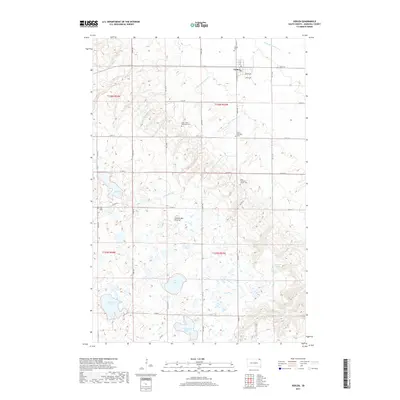
2017 Map of Veblen
USGS Topo · Published 2017About this map
Veblen serves as the primary hub in this Marshall County landscape, where the flat plains give way to the glacial upland known as the Coteau des Prairies. This geographic transition is marked by a high density of wetlands and lakes, including Abraham Lake, Hill Lake, and Dumarce Lake, which collect across the undulating prairie. The drainage system is defined by the Little Minnesota River and tributaries like LaFrambois Cr, carving subtle valleys through the township. For family historians, the sheet is exceptionally detailed regarding local interment sites, documenting several rural locations such as Saint Luke's Episcopal Cem, Saint Matthew's Church Cem, and Zion Cem. The grid of section lines and county roads, including Co HWY 6 and Co HWY 8, illustrates the enduring structure of South Dakota's agricultural land division.
Find a feature on this map
41 named features on this map. Tap any name to fly to it.
Don’t see what you’re looking for? This feature index may not catch every label — zoom into the map to look around manually.
Map Details
Editions of this 2017 Veblen Map
This is the sole edition of this map. No revisions or reprints were ever made.
Other maps of this area

1953 · Milbank
USGS Topo · 1:250,000

1958 · Milbank
USGS Topo · 1:250,000

1958 · Hillhead
USGS Topo · 1:24,000

1958 · Veblen
USGS Topo · 1:24,000

1958 · Marlow
USGS Topo · 1:24,000

1958 · Veblen NE
USGS Topo · 1:24,000
1964 · Claire City NW
USGS Topo · 1:24,000

1964 · Claire City SW
USGS Topo · 1:24,000

1970 · Whitestone Lake
USGS Topo · 1:24,000

1970 · South Red Iron Lake
USGS Topo · 1:24,000