Loading...
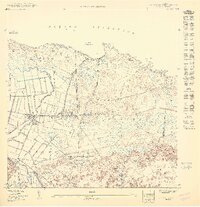
Loading map...1950 Map of Vega Alta NO
USGS Topo · Published 1950This historical map portrays the area of Vega Alta NO in 1950, primarily covering Vega Alta Municipio as well as portions of Vega Baja Municipio and Dorado Municipio. Featuring a scale of 1:10000, this map provides a highly detailed snapshot of the terrain, roads, buildings, counties, and historical landmarks in the Vega Alta NO region at the time. Published in 1950, it is the sole known edition of this map.
Map Details
Date Portrayed1950
Date Published1950
PublisherU.S. Geological Survey
Map TypeTopographic
Scale1:10000
Physical Dimensions30.67 x 31.69 inches
Editions of this 1950 Vega Alta NO Map
This is the sole edition of this map. No revisions or reprints were ever made.
Historical Maps of Golden Village Through Time
Featured Locations
- La Hormiga, Dorado
- Breñas, Vega Alta
- Villa Alegria, Vega Alta
- Golden Village, Vega Alta
- Almirante Norte, Vega Baja
Source Details
SourceU.S. Geological Survey
CopyrightPublic Domain