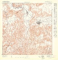
1947 Map of Vega Alta SO
USGS Topo · Published 1947About this map
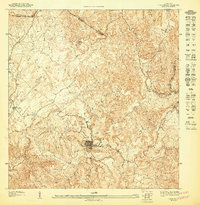
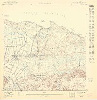
The sugar industry of the northern coast is central to this 1940s landscape, anchored by the Central Carmen processing facility and the narrow-gauge rail lines of the Porto Rico Sugar Company. These tracks wind through the alluvial plains of Bajura and Ceiba, following the meandering path of the Río Cibuco. The town of Vega Alta appears as a compact grid on the eastern edge of the Cibuco, positioned where the flat coastal lands meet the limestone hills.
Find a feature on this map
22 named features on this map. Tap any name to fly to it.
Don’t see what you’re looking for? This feature index may not catch every label — zoom into the map to look around manually.
Map Details
Editions of this 1947 Vega Alta SO Map
This is the sole edition of this map. No revisions or reprints were ever made.
Other maps of this area

1940 · Vega Alta
USGS Topo · 1:30,000

1942 · Manati
USGS Topo · 1:30,000

1946 · Corozal
USGS Topo · 1:30,000

1946 · Ciales
USGS Topo · 1:30,000

1946 · Vega Alta
USGS Topo · 1:30,000
1946 · Manati
USGS Topo · 1:30,000
1947 · Corozal NO
USGS Topo · 1:10,000
1947 · Corozal NE
USGS Topo · 1:10,000
1947 · Ciales NE
USGS Topo · 1:10,000
1950 · Vega Alta NO
USGS Topo · 1:10,000
Featured Places
- Vega Alta, Vega Alta
- Maricao Adentro, Vega Alta
- Sector Boquerón, Vega Alta
- El Nueve, Vega Alta
- Villa Joselí, Vega Alta