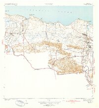
1940 Map of Vega Alta
USGS Topo · Published 1940About this map
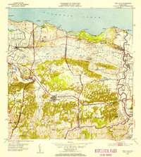
The American Railroad of Porto Rico defines the industrial corridor of this northern coastal region, connecting the sugar-processing centers of Central San Vicente, Central Carmen, and Central Constancia. Surveyed just before the 1940s, the map reveals a landscape dominated by agriculture and colonial estates such as Colonia Maris Miña, with the rail line serving as the primary artery for the towns of Vega Alta, Dorado, and Toa Baja. Coastal settlements like Poblado Cerro Gordo sit near the Atlantic Ocean shoreline, while inland, the topography is characterized by the distinctive karst haystack hills rising above the floodplains of the Rio La Plata and Rio Cibuco. A small Airport and specialized stops like Estacion Toa Baja illustrate the infrastructure supporting the local economy during this era.
Find a feature on this map
42 named features on this map. Tap any name to fly to it.
Don’t see what you’re looking for? This feature index may not catch every label — zoom into the map to look around manually.
Map Details
Editions of this 1940 Vega Alta Map
2 editions found
Historical Maps of Dorado Through Time
8 maps found