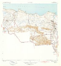
1940 Map of Vega Alta
USGS Topo · Published 1940About this map
Industrial sugar processing dominates the coastal plains of northern Puerto Rico in this 1940 survey, which details the infrastructure of Central San Vicente, Central Constancia, and Central Carmen. The American Railroad of Porto Rico serves as the primary artery for transportation, linking Estacion Dorado and Estacion Toa Baja with the surrounding agricultural lands. The landscape is a mix of marshy lowlands like Cienaga Prieta and the knobby hills of the Cerros de Higuillar.
Find a feature on this map
45 named features on this map. Tap any name to fly to it.
Don’t see what you’re looking for? This feature index may not catch every label — zoom into the map to look around manually.
Map Details
Editions of this 1940 Vega Alta Map
2 editions found
Other maps of this area

1940 · Vega Alta
USGS Topo · 1:30,000

1941 · Bayamon
USGS Topo · 1:30,000

1942 · Manati
USGS Topo · 1:30,000

1946 · Corozal
USGS Topo · 1:30,000

1946 · Ciales
USGS Topo · 1:30,000

1946 · Vega Alta
USGS Topo · 1:30,000

1946 · Naranjito
USGS Topo · 1:30,000

1946 · Manati
USGS Topo · 1:30,000

1947 · Corozal NO
USGS Topo · 1:10,000
1947 · Corozal NE
USGS Topo · 1:10,000