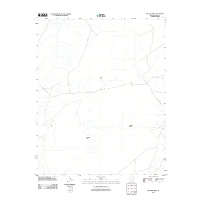
2011 Map of Ventana Mesa
USGS Topo · Published 2011About this map
Ventana Mesa dominates this high-altitude landscape in the Apache County region of Arizona, characterized by a series of prominent landforms and high plateaus. The 2011 survey documents a sparse network of roads, including Indian Rte 8090 and Bia Route 8090, which weave through the desert terrain to connect local points of interest. Notable geographic markers such as Hope Arch and the jagged edge of the Red Rock Rim provide essential orientation in this open country. The presence of Tse Abe I further emphasizes the cultural and geographical distinctiveness of the area. This topographic record serves as a primary reference for the road infrastructure and natural landmarks within the Chinle Agency's jurisdiction during the early 21st century.
Find a feature on this map
7 named features on this map. Tap any name to fly to it.
Don’t see what you’re looking for? This feature index may not catch every label — zoom into the map to look around manually.
Map Details
Editions of this 2011 Ventana Mesa Map
This is the sole edition of this map. No revisions or reprints were ever made.
Other maps of this area

1892 · Canyon De Chelly
USGS Topo · 1:250,000

1954 · Shiprock
USGS Topo · 1:250,000

1955 · Chinle 4 NE
USGS Topo · 1:24,000

1955 · Chinle 4 SE
USGS Topo · 1:24,000

1958 · Shiprock
USGS Topo · 1:250,000

1959 · Shiprock
USGS Topo · 1:250,000

1968 · Many Farms SW
USGS Topo · 1:24,000
1968 · Many Farms
USGS Topo · 1:24,000
1968 · Sweathouse Peak
USGS Topo · 1:24,000
1972 · Ventana Mesa
USGS Topo · 1:24,000