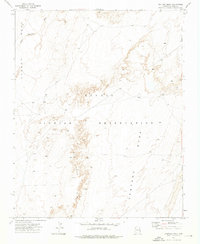
1972 Map of Ventana Mesa
USGS Topo · Published 1976About this map
Navajo Indian Reservation lands dominate this topographical study from the early 1970s, where the dramatic sandstone geometry of the high desert is meticulously documented. The landscape is defined by the massive uplift of Ventana Mesa and the sharp drop-offs of the Red Rock Rim, which together create a complex network of canyons and plateaus. These natural barriers dictated the movement and settlement patterns within this corner of Apache County, visible in the winding paths of the unnamed Wash systems and the isolated landmark of Tse Abe I. Along the eastern edge of the quadrangle, the Old Indian Reservation Boundary marks a historical demarcation line that predates the modern extent of the reservation. The map also records the transition between Carson Mountain and the northeastern reaches of Black Mesa, providing a clear look at the geological structures that shaped indigenous land use and high-altitude grazing in this era.
Find a feature on this map
9 named features on this map. Tap any name to fly to it.
Don’t see what you’re looking for? This feature index may not catch every label — zoom into the map to look around manually.
Map Details
Editions of this 1972 Ventana Mesa Map
This is the sole edition of this map. No revisions or reprints were ever made.
Other maps of this area

1892 · Canyon De Chelly
USGS Topo · 1:250,000

1954 · Shiprock
USGS Topo · 1:250,000

1955 · Chinle 4 NE
USGS Topo · 1:24,000

1955 · Chinle 4 SE
USGS Topo · 1:24,000

1958 · Shiprock
USGS Topo · 1:250,000

1959 · Shiprock
USGS Topo · 1:250,000

1968 · Many Farms SW
USGS Topo · 1:24,000
1968 · Many Farms
USGS Topo · 1:24,000
1968 · Sweathouse Peak
USGS Topo · 1:24,000
1972 · Lohali Point
USGS Topo · 1:24,000