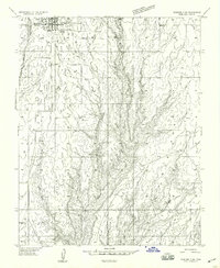
1959 Map of Verdure 3 SW
USGS Topo · Published 1959About this map
Blanding sits at the northern edge of this 1950s survey, showing a structured grid of streets and early municipal infrastructure like the Sewage Disposal plant and a nearby Canal. The landscape south of town transitions into the dramatic topography of White Mesa and Murphy Point, where the terrain is deeply incised by Westwater Creek and Recapture Creek. Evidence of ancient habitation and modern resource extraction appear side-by-side, with Cliff Dwellings marked along the canyon walls while a Gravel Pit and various Gravel Pits indicate mid-century industry. The map illustrates a rural economy reliant on water management and land use, noted by several Springs, a Well, and a Corral along Corral Creek. This preliminary edition captures the San Juan County landscape during a period of infrastructure expansion, balancing established town life with the stark geography of Brown Canyon.
Find a feature on this map
17 named features on this map. Tap any name to fly to it.
Don’t see what you’re looking for? This feature index may not catch every label — zoom into the map to look around manually.
Map Details
Editions of this 1959 Verdure 3 SW Map
This is the sole edition of this map. No revisions or reprints were ever made.
Other maps of this area

1886 · Abajo
USGS Topo · 1:250,000

1892 · Abajo
USGS Topo · 1:250,000

1893 · Abajo
USGS Topo · 1:250,000

1935 · Elk Ridge
USGS Topo · 1:96,000

1940 · Elk Ridge
USGS Topo · 1:125,000

1955 · Verdure 3 SE
USGS Topo · 1:24,000

1955 · Verdure 3 NE
USGS Topo · 1:24,000

1956 · Cortez
USGS Topo · 1:250,000
1957 · Elk Ridge 4 NE
USGS Topo · 1:24,000

1957 · Elk Ridge 4 SE
USGS Topo · 1:24,000