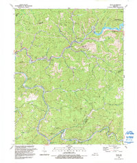
1992 Map of Vicco
USGS Topo · Published 1992About this map
The mountain settlements of Perry, Knott, and Letcher Counties are defined here by a dense network of hollows and ridge-line borders during the early 1990s. The coal-country landscape around Vicco is marked by numerous mines dotting the hillsides, illustrating the enduring industrial character of the Carr Fork and North Fork Kentucky River drainages. Local community life is centered on the valley floors, with landmarks such as Combs Sch at Happy, the New Tribes Mission Institute near Cornettsville, and Indian Bottom Ch near the southern bend of the river.
Find a feature on this map
50 named features on this map. Tap any name to fly to it.
Don’t see what you’re looking for? This feature index may not catch every label — zoom into the map to look around manually.
Map Details
Editions of this 1992 Vicco Map
This is the sole edition of this map. No revisions or reprints were ever made.
Other maps of this area

1890 · Whitesburg
USGS Topo · 1:125,000

1891 · Hazard
USGS Topo · 1:125,000

1892 · Whitesburg
USGS Topo · 1:125,000

1912 · Hindman
USGS Topo · 1:48,000

1913 · Oven Fork
USGS Topo · 1:48,000

1914 · Troublesome
USGS Topo · 1:62,500

1915 · Hindman
USGS Topo · 1:62,500

1915 · Whitesburg
USGS Topo · 1:62,500

1916 · Cornettsville
USGS Topo · 1:62,500
1954 · Hindman
USGS Topo · 1:24,000