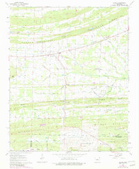
1963 Map of Vilonia
USGS Topo · Published 1982About this map
Vilonia serves as the primary hub of this landscape, situated at the confluence of the North Fork and Middle Fork of Little Cypress Creek. The area is defined by its distinct series of ridges and gaps, notably Cadron Ridge and Wilson Hill, which dictated the early settlement and road patterns. Local community life in the mid-20th century is evident through several rural churches and burial sites, such as Mt Carmel Ch and the Duncan Gap Cem. To the south, the terrain transitions toward Bayou Meto near the Faulkner and Pulaski county line. This 1963 survey, with revisions from 1975 and 1980, captures the rural character of the region before significant modern suburban expansion, preserving the locations of family landmarks like House Gap and Billy Goat Hill.
Find a feature on this map
58 named features on this map. Tap any name to fly to it.
Don’t see what you’re looking for? This feature index may not catch every label — zoom into the map to look around manually.
Map Details
Editions of this 1963 Vilonia Map
3 editions found
Other maps of this area

1891 · Little Rock
USGS Topo · 1:125,000

1893 · Little Rock
USGS Topo · 1:125,000

1941 · Olmstead
USGS Topo · 1:31,680

1941 · Cabot
USGS Topo · 1:31,680

1953 · Cato
USGS Topo · 1:24,000

1954 · Olmstead
USGS Topo · 1:24,000
1954 · Cabot
USGS Topo · 1:24,000

1955 · Little Rock
USGS Topo · 1:250,000

1956 · Little Rock
USGS Topo · 1:250,000

1956 · Russellville
USGS Topo · 1:250,000