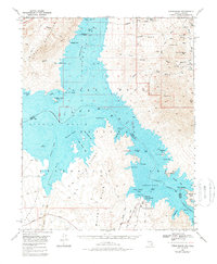
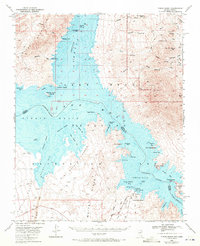
1970 Map of Virgin Basin
USGS Topo · Published 1980About this map
Virgin Basin and Temple Basin form a dramatic flooded landscape where the Colorado River and Virgin River meet within the Lake Mead National Recreation Area. This 1970 revision of a mid-century survey documents the rising waters around the Gypsum Ledges and White Hills, capturing the early recreational footprint of the region. The map details remote access points such as Temple Bar Marina, which features a Landing Field and the Temple Bar Boat Anchorage, alongside traces of the area's pioneer and prospecting past.
Find a feature on this map
76 named features on this map. Tap any name to fly to it.
Don’t see what you’re looking for? This feature index may not catch every label — zoom into the map to look around manually.
Map Details
Editions of this 1970 Virgin Basin Map
2 editions found
Other maps of this area

1886 · Camp Mohave
USGS Topo · 1:250,000

1886 · Saint Thomas
USGS Topo · 1:250,000

1892 · Camp Mohave
USGS Topo · 1:250,000

1893 · Saint Thomas
USGS Topo · 1:250,000

1926 · Nelson
USGS Topo · 1:96,000

1926 · Bonelli
USGS Topo · 1:96,000

1926 · Boulder Canyon
USGS Topo · 1:96,000

1942 · Camp Mohave
USGS Topo · 1:250,000

1947 · Kingman
USGS Topo · 1:250,000

1948 · Kingman
USGS Topo · 1:250,000