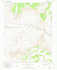
1980 Map of Virgin
USGS Topo · Published 1980About this map
Virgin River carves a deep path through the center of this 1980 survey, providing the lifeblood for the settlement of Virgin. To the north and south, the terrain is dominated by high plateau structures, including Hurricane Mesa, Smith Mesa, and Gooseberry Mesa. The agricultural and technical development of the region is evident through features like the Hurricane Canal and a specialized Test Track situated on the high flats near a Landing Strip. Smaller pockets of habitation like Mountain Dell appear tucked away in the drainage of North Creek, while signs of resource exploration are found at Oil Wells and a Drill Hole. The transition from the Little Plain to the fractured edges of Pastry Ridge illustrates the complex geology of Washington County.
Find a feature on this map
20 named features on this map. Tap any name to fly to it.
Don’t see what you’re looking for? This feature index may not catch every label — zoom into the map to look around manually.
Map Details
Editions of this 1980 Virgin Map
This is the sole edition of this map. No revisions or reprints were ever made.
Other maps of this area

1885 · St. George
USGS Topo · 1:250,000

1891 · St. George
USGS Topo · 1:250,000

1953 · Cedar City
USGS Topo · 1:250,000

1954 · La Verkin 4 SE
USGS Topo · 1:24,000

1954 · La Verkin 4 NW
USGS Topo · 1:24,000

1954 · La Verkin 4 SW
USGS Topo · 1:24,000

1954 · La Verkin 3 NE
USGS Topo · 1:24,000

1954 · La Verkin 1 SW
USGS Topo · 1:24,000

1954 · La Verkin 3 SE
USGS Topo · 1:24,000

1954 · La Verkin 2 SE
USGS Topo · 1:24,000