1921 Map of Volta
USGS Topo · Published 1921About this map
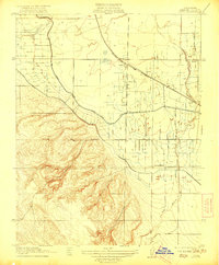
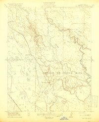
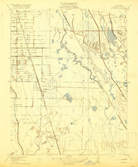
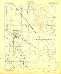
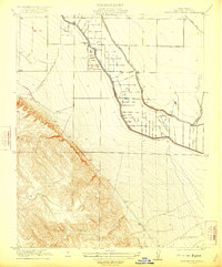
Volta stands as a rail-side hub in this 1920s Merced County landscape, positioned along the Southern Pacific line where irrigation and topography meet. The map reveals an intensive water management system essential for San Joaquin Valley agriculture, dominated by the San Joaquin and Kings River Canal as it skirts the base of the western hills. This transition from the flat, canal-fed valley floor to the elevated terrain of Washboard Road illustrates the geographical divide between irrigated farmland and the higher rangeland. Local education and community life are anchored by the Monroe School in the north and Sunset School to the south, while the small settlement of Trent sits near the winding course of Los Banos Creek. Natural drainage is further defined by the meandering San Luis Cr, providing a detailed look at the hydrology of the region before modern large-scale development.
Find a feature on this map
12 named features on this map. Tap any name to fly to it.
Don’t see what you’re looking for? This feature index may not catch every label — zoom into the map to look around manually.
Map Details
Editions of this 1921 Volta Map
This is the sole edition of this map. No revisions or reprints were ever made.
Other maps of this area

1913 · Panoche
USGS Topo · 1:125,000
1919 · San Luis Ranch
USGS Topo · 1:31,680
1919 · Ingomar
USGS Topo · 1:31,680

1920 · Pacheco Pass
USGS Topo · 1:62,500

1920 · Carrisalito Spring
USGS Topo · 1:31,680
1921 · Los Banos
USGS Topo · 1:31,680
1922 · Charleston School
USGS Topo · 1:31,680
1922 · Quien Sabe
USGS Topo · 1:62,500
1922 · San Luis Creek
USGS Topo · 1:31,680
1922 · Ortigalita
USGS Topo · 1:31,680