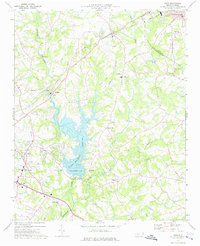
1973 Map of Waco
USGS Topo · Published 1976About this map
Kings Mountain Reservoir dominates the central landscape of this Cleveland County region, formed by the impoundment of Buffalo Creek. The 1970s terrain is a mix of traditional agriculture and expanding institutional development, evidenced by the Cleveland County Technical Institute and the nearby County Fairgrounds. The rail-centered community of Waco and the town of Cherryville anchor the northern reaches, while the Seaboard Coast Line railroad carves through the undulating topography. Genealogists will find a dense network of country churches and family landmarks, including Marys Grove Ch, Hullender Cem, and the community of Stubbs. The presence of the Drag Strip and multiple Golf Courses reflects the mid-century recreational shift in this rural North Carolina corridor near the Gaston County line.
Find a feature on this map
42 named features on this map. Tap any name to fly to it.
Don’t see what you’re looking for? This feature index may not catch every label — zoom into the map to look around manually.
Map Details
Editions of this 1973 Waco Map
This is the sole edition of this map. No revisions or reprints were ever made.
Other maps of this area

1906 · Kings Mountain
USGS Topo · 1:62,500

1908 · Kings Mountain
USGS Topo · 1:62,500

1909 · Gaffney
USGS Topo · 1:62,500

1909 · Lincolnton
USGS Topo · 1:62,500

1911 · Lincolnton
USGS Topo · 1:62,500

1950 · Shelby
USGS Topo · 1:62,500

1953 · Charlotte
USGS Topo · 1:250,000

1954 · Charlotte
USGS Topo · 1:250,000

1960 · Charlotte
USGS Topo · 1:250,000

1962 · Charlotte
USGS Topo · 1:250,000