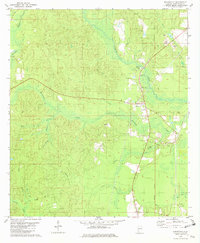
1982 Map of Wagarville
USGS Topo · Published 1982About this map
The St Stephens Meridian serves as a primary surveying backbone for this portion of Alabama, bisecting a landscape defined by the drainage basins of Bassetts Creek and Armstrong Creek. In the early 1980s, Wagarville stands as a central settlement, flanked by rural communities like Cortelyou and Sunflower. The area's spiritual life is mapped through numerous small country sanctuaries, including Cedar Grove Ch, Victory Grove Ch, and Mt Shady Ch.
Find a feature on this map
26 named features on this map. Tap any name to fly to it.
Don’t see what you’re looking for? This feature index may not catch every label — zoom into the map to look around manually.
Map Details
Editions of this 1982 Wagarville Map
This is the sole edition of this map. No revisions or reprints were ever made.
Other maps of this area

1943 · Choctaw Bluff
USGS Topo · 1:62,500

1943 · McIntosh
USGS Topo · 1:62,500

1944 · McIntosh
USGS Topo · 1:62,500

1946 · Choctaw Bluff
USGS Topo · 1:62,500

1953 · Andalusia
USGS Topo · 1:250,000

1953 · Hattiesburg
USGS Topo · 1:250,000

1957 · Andalusia
USGS Topo · 1:250,000

1958 · Hattiesburg
USGS Topo · 1:250,000

1971 · Bigbee
USGS Topo · 1:24,000

1972 · St. Stephens
USGS Topo · 1:24,000