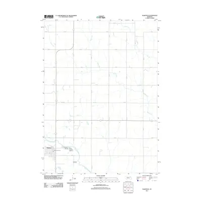
2011 Map of Wakefield
USGS Topo · Published 2011About this map
Wakefield serves as the primary hub of this northeastern Nebraska landscape, which is defined by an extensive grid of section roads and several meandering waterways. The town layout is clearly defined, featuring the Wakefield Post Office as a central waypoint. Just to the southeast, the Logan Valley Golf Course occupies a stretch of land near the Logan Creek Dredge, a modified waterway that hints at the region's agricultural drainage history. The surrounding countryside is drained by several distinct creek systems, including Myrtle Creek, Sand Creek, and Middle Creek, which flow through the agricultural blocks. The road network is strictly rectilinear, composed of numbered avenues and roads like Ekberg Rd, reflecting the systematic land division typical of the Great Plains. This survey captures the area's modern rural character, where small-town life meets the structured efficiency of Nebraska's farming heartland.
Find a feature on this map
26 named features on this map. Tap any name to fly to it.
Don’t see what you’re looking for? This feature index may not catch every label — zoom into the map to look around manually.
Map Details
Editions of this 2011 Wakefield Map
This is the sole edition of this map. No revisions or reprints were ever made.
Other maps of this area

1955 · Sioux City
USGS Topo · 1:250,000

1958 · Sioux City
USGS Topo · 1:250,000

1959 · Sioux City
USGS Topo · 1:250,000

1966 · Altona NW
USGS Topo · 1:24,000

1966 · Thurston
USGS Topo · 1:24,000

1966 · Altona NE
USGS Topo · 1:24,000

1967 · Waterbury
USGS Topo · 1:24,000
1967 · Allen
USGS Topo · 1:24,000

1967 · Wakefield SW
USGS Topo · 1:24,000
1967 · Wakefield
USGS Topo · 1:24,000
Featured Places
- Wakefield, NE
- Springbank Township, NE
- Saint Johns Trailer Court, Wakefield
- Emerson Township, NE
- Wakefield Township, NE