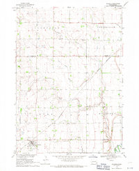
1968 Map of Wakonda
USGS Topo · Published 1971About this map
The town of Wakonda serves as a focal point in this portion of Clay County, showing the intersection of local commerce and the Chicago and North Western railway lines in the late 1960s. The landscape is defined by the township divisions of Daneville, Centerville, Star, and Riverside, which organize the agrarian territory. Water management is evident through the network of Ditch systems and Bonine Ditch that feed into Frog Creek and Spring Creek, eventually reaching the Vermillion River in the southeast corner. For those researching local heritage, the map identifies several spiritual and commemorative sites, including Immanuel Ch, Holland Cem, and Columkill Cem. The inclusion of an Old Railroad Grade and a Gravel Pit indicates the changing infrastructure and small-scale industry of the era, while Colfax Corner marks a distinct crossroads in the rural grid.
Find a feature on this map
19 named features on this map. Tap any name to fly to it.
Don’t see what you’re looking for? This feature index may not catch every label — zoom into the map to look around manually.
Map Details
Editions of this 1968 Wakonda Map
This is the sole edition of this map. No revisions or reprints were ever made.
Other maps of this area

1897 · Canton
USGS Topo · 1:125,000

1898 · Parker
USGS Topo · 1:125,000

1898 · Elk Point
USGS Topo · 1:125,000

1900 · Canton
USGS Topo · 1:125,000

1901 · Elk Point
USGS Topo · 1:125,000

1907 · Elk Point
USGS Topo · 1:125,000

1955 · Sioux City
USGS Topo · 1:250,000

1955 · Sioux Falls
USGS Topo · 1:250,000

1957 · Gayville
USGS Topo · 1:24,000

1958 · Sioux City
USGS Topo · 1:250,000