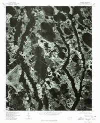
1976 Map of Wakulla
USGS Topo · Published 1978About this map
Floral College and the winding course of the Lumber River define this mid-1970s orthophotoquad of Robeson County. Unlike traditional topographic maps, this imagery-based study reveals the intricate drainage patterns and Carolina bay-like depressions that characterize this stretch of the Inner Coastal Plain. The settlement of Wakulla sits at the edge of these wetlands, where agricultural fields are carved out of the dense forest cover along the river corridor. This specific format, produced in cooperation with the Soil Conservation Service, offers an unfiltered look at land use and drainage during a period of significant regional farming activity. Researchers can observe the exact footprint of early educational landmarks like Floral College and trace the original meanders of the river before modern hydrological changes.
Find a feature on this map
4 named features on this map. Tap any name to fly to it.
Don’t see what you’re looking for? This feature index may not catch every label — zoom into the map to look around manually.
Map Details
Editions of this 1976 Wakulla Map
This is the sole edition of this map. No revisions or reprints were ever made.
Other maps of this area

1949 · Wagram
USGS Topo · 1:24,000

1949 · Laurinburg
USGS Topo · 1:24,000

1949 · Silver Hill
USGS Topo · 1:24,000

1949 · Wakulla
USGS Topo · 1:24,000

1949 · Laurinburg
USGS Topo · 1:62,500

1953 · Florence
USGS Topo · 1:250,000

1954 · Florence
USGS Topo · 1:250,000

1957 · Laurinburg
USGS Topo · 1:24,000

1971 · Johns
USGS Topo · 1:24,000
1972 · Raeford
USGS Topo · 1:24,000