1900 Map of Walsenburg
USGS Topo · Published 1900About this map
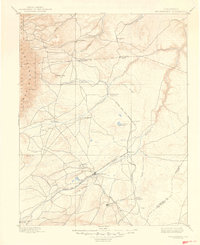
The Greenhorn Mountains anchor the western edge of this landscape, where the high plains meet the dramatic rise of the Rockies. In the late nineteenth century, the region's economy was increasingly shaped by the convergence of rail lines and early mining settlements. Walsenburg serves as the central hub, situated near Walsen Crag and the Colorado and Southern RR. The map captures the importance of water and transport in this arid environment, showing the winding course of the Huerfano River and the critical junction at Huerfano Sta. (Ute P.O.). To the south, the La Veta Branch of the railroad heads toward La Veta, while mining activity is signaled by settlements like Pictou and Rouse. This survey documents a transitional era where traditional ranching and post offices like Apache coexisted with the industrializing influence of the coal-carrying railroads.
Find a feature on this map
38 named features on this map. Tap any name to fly to it.
Don’t see what you’re looking for? This feature index may not catch every label — zoom into the map to look around manually.
Map Details
Editions of this 1900 Walsenburg Map
This is the sole edition of this map. No revisions or reprints were ever made.
Historical Maps of Walsenburg Through Time
5 maps found