
1892 Map of Elmoro
USGS Topo · Published 1892About this map
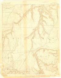
Trinidad and Elmoro anchor the southern reaches of this 1889 survey, where the valley floor meets the imposing Raton Mesa and the prominent landmark of Fisher Peak. The regional economy is clearly defined by early rail corridors and water access, with the Purgatoire River cutting across the central plains and providing a lifeline for settlements like Hoehne. Three major rail lines converge in this landscape: the Atchison Topeka and Santa Fe Railroad enters from the north via Tyrone, while the Denver Texas and Fort Worth Railroad and the D. & R. G. R. R. support the southern coal and transit hubs. Smaller communities such as Barela, Adair, and Trinchera mark the eastern reaches, connected by a network of creeks and arroyos including San Francisco Creek and Frijole Creek.
Find a feature on this map
24 named features on this map. Tap any name to fly to it.
Don’t see what you’re looking for? This feature index may not catch every label — zoom into the map to look around manually.
Map Details
Editions of this 1892 Elmoro Map
This is the sole edition of this map. No revisions or reprints were ever made.
Other maps of this area

1891 · Walsenburg
USGS Topo · 1:125,000

1891 · Spanish Peaks
USGS Topo · 1:125,000

1891 · Timpas
USGS Topo · 1:125,000

1891 · Apishapa
USGS Topo · 1:125,000

1891 · Mesa De Maya
USGS Topo · 1:125,000

1893 · Spanish Peaks
USGS Topo · 1:125,000

1893 · Apishapa
USGS Topo · 1:125,000

1893 · Elmoro
USGS Topo · 1:125,000
1893 · Mesa de Maya
USGS Topo · 1:125,000
1894 · Timpas
USGS Topo · 1:125,000