
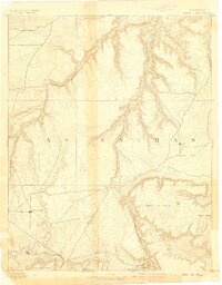
1891 Map of Mesa De Maya
USGS Topo · Published 1891About this map
Deep canyons and isolated mesas define this 1890 survey of the high plains in Las Animas County. The terrain is dominated by the massive Mesa De Maya, which towers over the surrounding landscape alongside Chicorico Mesa and the Black Buttes. Settlement is sparse, represented by small outposts such as Troy and Indianapolis, while the Denver Texas & Ft Worth railroad cuts across the southwestern corner near Watervale. This mapping captures a transitional era when the open range was increasingly segmented by rail and cattle ranching, illustrated by the network of named drainages like Chaquaqua Canon, Lobo Canon, and Vachita Canon. The presence of West Carrizo Creek and Chaguaqua Creek highlights the critical importance of water sources in this arid ranching country just before the turn of the century.
Find a feature on this map
19 named features on this map. Tap any name to fly to it.
Don’t see what you’re looking for? This feature index may not catch every label — zoom into the map to look around manually.
Map Details
Editions of this 1891 Mesa De Maya Map
This is the sole edition of this map. No revisions or reprints were ever made.
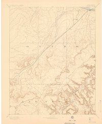
Other maps of this area

1891 · Higbee
USGS Topo · 1:125,000

1891 · Timpas
USGS Topo · 1:125,000

1891 · Apishapa
USGS Topo · 1:125,000

1892 · Elmoro
USGS Topo · 1:125,000

1892 · Mt Carrizo
USGS Topo · 1:125,000

1893 · Higbee
USGS Topo · 1:125,000

1893 · Apishapa
USGS Topo · 1:125,000

1893 · Elmoro
USGS Topo · 1:125,000
1893 · Mesa de Maya
USGS Topo · 1:125,000
1894 · Timpas
USGS Topo · 1:125,000