
1893 Map of Elmoro
USGS Topo · Published 1893About this map
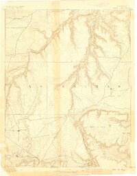
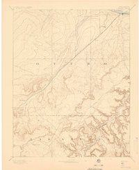
The high plains and rugged mesas of Southern Colorado converge at Trinidad, a critical rail and river junction just before the turn of the century. The Purgatoire River cuts a diagonal path through the landscape, flanked by the Atchison Topeka and Santa Fe Railroad and the Denver Texas and Fort Worth Railroad, which provided essential connections for the region's early mining and ranching economy.
Find a feature on this map
22 named features on this map. Tap any name to fly to it.
Don’t see what you’re looking for? This feature index may not catch every label — zoom into the map to look around manually.
Map Details
Editions of this 1893 Elmoro Map
This is the sole edition of this map. No revisions or reprints were ever made.
Other maps of this area

1891 · Walsenburg
USGS Topo · 1:125,000

1891 · Spanish Peaks
USGS Topo · 1:125,000

1891 · Timpas
USGS Topo · 1:125,000

1891 · Apishapa
USGS Topo · 1:125,000

1891 · Mesa De Maya
USGS Topo · 1:125,000

1892 · Elmoro
USGS Topo · 1:125,000

1893 · Spanish Peaks
USGS Topo · 1:125,000

1893 · Apishapa
USGS Topo · 1:125,000
1893 · Mesa de Maya
USGS Topo · 1:125,000
1894 · Timpas
USGS Topo · 1:125,000