
1893 Map of Spanish Peaks
USGS Topo · Published 1893About this map
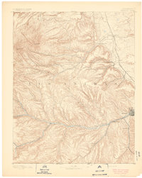
The East Spanish Peak and West Spanish Peak dominate the northwestern skyline of this 1889 survey, casting long shadows over the high plains of Las Animas County. Early settlement patterns follow the vital water sources of the Purgatoire River and the Apishapa River, where small communities like Madrid and Cordova emerged. Near the eastern edge, the burgeoning city of Trinidad serves as a critical regional hub, supported by the Denver Texas and Fort Worth Railroad which snakes through the canyonlands.
Find a feature on this map
36 named features on this map. Tap any name to fly to it.
Don’t see what you’re looking for? This feature index may not catch every label — zoom into the map to look around manually.
Map Details
Editions of this 1893 Spanish Peaks Map
2 editions found
Other maps of this area

1889 · Huerfano Park
USGS Topo · 1:125,000

1891 · Walsenburg
USGS Topo · 1:125,000

1891 · Spanish Peaks
USGS Topo · 1:125,000

1891 · Apishapa
USGS Topo · 1:125,000

1892 · Huerfano Park
USGS Topo · 1:125,000

1892 · Elmoro
USGS Topo · 1:125,000

1893 · Apishapa
USGS Topo · 1:125,000

1893 · Elmoro
USGS Topo · 1:125,000

1894 · Walsenburg
USGS Topo · 1:125,000

1895 · Spanish Peaks
USGS Topo · 1:125,000