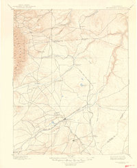
1894 Map of Walsenburg
USGS Topo · Published 1894About this map
The Denver and Rio Grande Railroad serves as the industrial spine of this late 19th-century Colorado landscape, branching through the high plains and foothills of the Southern Rockies. Centered on Walsenburg, the map documents a region in transition as coal mining and rail infrastructure define new settlement patterns near the foot of the mountains. To the south, the presence of the Rouse Mines and nearby Rouse Junction and Tioga highlights the era’s extractive economy. Water sources like the Huerfano River and Cuchara River carve through the terrain, with Cuchara Junction marking a critical node where the rails follow the natural topography. From the early settlement at Rye to prominent landmarks like Huerfano Butte, the survey captures a detailed view of Huerfano and Pueblo counties before the turn of the century.
Find a feature on this map
28 named features on this map. Tap any name to fly to it.
Don’t see what you’re looking for? This feature index may not catch every label — zoom into the map to look around manually.
Map Details
Editions of this 1894 Walsenburg Map
This is the sole edition of this map. No revisions or reprints were ever made.
Historical Maps of Walsenburg Through Time
5 maps found